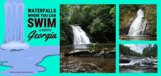
As a child of the Blue Ridge mountains, I grew up on twisty, curvy, mountain roads. My paw-paw Don had a saying that, “anyone can make a straight road, but it takes a damn good one to make a curvy road.”
To this day, I’m not sure if he meant that as a compliment to the engineers or a lament about of the lack of any straight roads in the mountains. However, one thing is definitely true: the curvy roads in the Appalachian mountains offer some of the most interesting and best scenic road trips in the USA!

One could argue that all of the roads in the North Georgia mountains are technically “scenic roads.” The views seem to get better and better as you travel higher into the mountains and deeper into the forests. Enjoy the views and vibes on these scenic drives in the Georgia mountains.
Map of North Georgia Mountains Scenic Drives
These scenic mountain routes in North Georgia are thrilling rides at any time of year, but they burst with color (and more traffic) during the peak Fall season. Use the interactive Georgia scenic drives map below to get an idea of where to find Georgia’s most scenic mountain roads and plan your scenic road trip!
Hint: use the map menu (top left) to hide / display different routes or points of interest.
There are many beautiful roads throughout the Georgia mountains, but some of the most recognized are the designated scenic drives along Georgia state highways. These 2-lane highways are well maintained and easy to find on a map.
Scenic Mountain Drives in Georgia
The North Georgia mountains have a lot of different options for scenic driving. There are scenic routes on wide open divided highways and beautiful natural scenes along some of the secluded one-lane gravel roads. The drives featured below are all on paved roads and travel past some of the most scenic places in Georgia.
North Georgia Dragon Eyes Scenic Route
One of the most famous (and most curvy) scenic drives in North Georgia is known as Georgia’s Dragon Eyes. This thrilling drive consists of 2 twisty loops (the dragon’s “eyes”) and boasts 77 miles, 715 curves, and 6 mountain gaps!
Learn more below about the two scenic loops of Georgia’s Dragon Eyes and the amazing curvy roads that attract drivers from all over the world. Shine up your favorite wheels and head out for the thrilling rides that go up, down, around, and through the North Georgia mountains.
Northern Loop / Russell-Brasstown National Scenic Byway

The northern / northeastern loop of Dragon Eyes is very closely aligned with the Russell-Brasstown National Scenic Byway. The main difference is that Russell-Brasstown route includes an additional stop at Georgia’s highest peak, Brasstown Bald (4,374′). This section of the scenic route is just over 40 miles long and includes almost 40 switchbacks!

Enjoy numerous natural points of interest along the route including:
- Brasstown Bald – visit Georgia’s tallest peak and see 360° panoramic views from the observation deck ($5 / person)
- Anna Ruby Falls (0.5 mile hike – $3 / person ages 16+)
- Dukes Creek Falls (2 mile hike – $4 / vehicle)
- Raven Cliff Falls (5 mile hike – $5 / vehicle)
Southern Loop / Scenic Loop 60 / 180 / 129 / 19
This scenic route goes through 3 gaps (Neels Gap 3,120′, Woody Gap 3,183′, and Wolfpen Gap 3,310′) and intersects the famous Appalachian Trail at both Woody Gap and Neels Gap. Stop at the well-known Mountain Crossings outfitters at Neels Gap and see the only place where the Appalachian Trail passes through the inside of the building (it’s the only covered portion of the entire 2,100-mile trail)!

Continue the twisty ride on Georgia’s Dragon along the Suches route. Stope at Chestatee Overlook and Woody Gap scenic overlook to give the driver a chance to pause and enjoy the wide open mountain and valley views. Notable points of interest along this route include:
- Desoto Falls ($5 / vehicle)
- Vogel State Park ($5 parking fee)
- Mountain Crossings at Walasi-Yi on the Appalachian Trail
Cohutta-Chattahoochee Scenic Byway
Discover Native American history and trace the steps of the US Civil War to Georgia’s “Apple Capital” of Ellijay on the 54-mile Cohutta-Chattahoochee Scenic Byway. Start at the historic Prater’s Mill in Whitfield County, then follow the scenic byway past rolling bucolic scenes of quiet country roads and the Cohutta Mountains in the Chattahoochee National Forest.
Chatsworth to Ellijay on GA 52
- Fort Mountain State Park explore and learn more about the mysterious Native American history and ancient rock wall on the highest point of the mountain
Southern Highroads Trail
The Southern Highroads Trail is a multi-state route that runs through mountain towns and tourist attractions in 4 states (Georgia, North Carolina, South Carolina, and Tennessee).

Take US Highway 76 West from the South Carolina border all the way to apple country in Ellijay, then turn right to wander North on Highway 411 towards Tennessee. Stop along the way to enjoy the scenic Georgia towns including Clayton, Tiger, and Blue Ridge. The Southern Highroads Trail route overlaps / includes part of or all of many of North Georgia’s other scenic routes including Georgia Scenic Highway 197, Cohutta-Chattahoochee Scenic Byway, and Highway 441 from Baldwin to Clayton.
Georgia Mountain Parkway (GA 515 / US 76)
One of the easiest scenic drives in the Georgia mountains is the Georgia Mountain Parkway along GA 515 / US 76. These scenic highways of North Georgia start where I-575 ends then travel along into the beautiful North Georgia mountains and towns. This 4-lane divided highway is the main thoroughfare that connects the mountain towns of Ellijay, Blue Ridge, Blairsville, and Hiawassee.

Follow the map along the scenic Georgia Mountain Parkway or explore one of the other scenic routes marked on the official parkway map. Enjoy views of mountains, trees, and wildflowers while sampling local treats like apple orchards, festivals, antique shops, and gorgeous outdoor spaces!
Georgia Scenic 197 (GA 197)
This 27-mile scenic route is part of the Southern Highroads Trail and includes dozens of options for unique shopping and sight seeing.
Head into the Chattahoochee-Oconee National Forest and you’ll be rewarded with some pretty killer turns. Get out of your car, though, and you’ll see gorgeous scenery like this. The highway was a moonshine route back in the day (the day in this case being Prohibition) but is now known more as a destination for artisanal pottery, stained glass, and wood furniture. Moccasin Creek State Park is your go-to for camping, hiking, and fishing — there’s even a trout fishery you can tour — and Lake Burton is where you can put a day trip inside your road trip with boating, kayaking, stand-up paddleboarding, and all the lake-related activities.
- Mark of the Potter: +1 (706) 947-3440
- Hickory Flat Pottery: +1 (706) 947-0030
- Moccasin Creek State Park
Old 76 to Blairsville
Warwoman Road
Warwoman Road is a 16-mile scenic drive from Clayton to Pine Mountain that follows Warwoman Shear, a ancient geologic feature that provided an east-west trading route for Native Americans and early settlers.
- Warwoman Dell: enjoy a picnic area and an interactive trail about local history, legends, geography, and plant life
- Becky Branch Falls (0.5-mile on the Bartram Trail from parking lot)
- Martin Creek Falls (2-miles on the Bartram Trail from parking lot)
Tips for a Great Scenic Drive
Each of these routes will transport you to the scenic mountain playgrounds of North Georgia. Be sure to follow a few smart guidelines to make the most of your trip!

Safety on Mountain Roads
These scenic drives in North Georgia are free to travel, suitable for most well-maintained cars (4-wheel drive is not required), and remain open year-round.
As you use this guide as a scenic road trip planner, keep in mind that the roads are busiest during the Fall when the leaves change colors and put on a spectacular show. Be aware that you will need to share the curvy mountain roads with bicycles and motorcycles and to expect more riders during milder weather (Spring and Fall).
Be Prepared
While these curvy mountain roads are a beautiful thrill ride for many people, there are ways to make the ride more enjoyable for everyone. Follow the steps below to make sure passengers are comfortable and safe on the scenic highways in Georgia.
Avoid Motion Sickness
For anyone prone to motion sickness, it is wise to take precautions to avoid feeling queasy on the road.
- Take Dramamine or other motion sickness medication BEFORE your trip (note that some medications may cause drowsiness)
- Let people who are prone to motion sickness ride in the front seat or drive
- Avoid looking down (at phone, map, etc.) when riding on curvy roads
- Provide motion sickness bags or containers (some roads have no shoulder to pull over for sick passengers)
Car Safety
Make sure that your vehicle is road-ready before heading out on your scenic drive. Do a car safety check and carry safety equipment to help in case of emergencies.
- Fill up with gas and check fluid levels (oil, coolant, washer fluid, brake fluid, power steering, transmission fluid)
- Check lights, signals, windshield wipers, tires (tread and air pressure), and brakes
- Clean car windows inside and out before departing (clean windows at each stop for the best views possible)
- Mount cell phone for hands-free use and set up a Bluetooth connection for calls – Georgia is a “hands-free” state and drivers may not use their hands to make calls or texts
Once your car is ready to go, carry useful items to assist others (or yourself) during emergencies including window cleaners, emergency LED flares, portable air compressors, and portable car battery chargers.
Personal safety
Whether or not you plan to do anything strenuous, it is helpful to plan for surprises and have a few helpful items in your car.
- Carry cash – some places (parking lots, parks, etc.) do not accept other forms of payment
- Carry water – do not drink from streams / rivers / lakes without proper filtration
- Have a first aid kit – keep basic items on hand to handle allergies, upset stomach, small cuts, insect bites, and personal health concerns
- Don’t count on cell service or data in remote areas
- Download digital maps for offline use or carry printed maps
- Expect cell batteries to drain faster when searching for a signal
Be Alert
- Observe speed limits – slow down when approaching curves or other areas that have warnings about lowered speed limits
- Share the road
- Bicyclists may legally use the roads but will generally move at much slower speeds than cars (especially up hills!)
- Motorcycles and bicycles can be hard to see
- Mind the sun – car visors may not be effective when curvy mountain roads change direction too frequently
- Wear a brimmed hat to shield eyes
- Wear polarized sunglasses to reduce glare
- Watch for wildlife – there is increased wildlife activity during rut seasons and there may be large animals like deer crossing the road
Staying Comfortable on Road Trips
There are certain things that you can do to have a more comfortable trip. Follow these tips for a great trip!
Clothing for Road Trips
Make sure to wear comfortable clothing that will travel well. Driving shoes are specifically designed to help the driver better feel the pedals for more control. Polarized sunglasses can prevent glare and provide better visibility on bright days. A hat with a brim can help shield eyes from the sun (especially helpful when the sun is low on the horizon). Long sleeves and pants can provide a layer of protection from the sun and prevent chafing from seat belts.
Road Trip Travel Tech
The more thrilling scenic roads are filled with multiple switchbacks and hairpin curves that will be fun to re-live through video from an HD dashcam. Cell phone mounts and Bluetooth speakers allow drivers to follow Georgia law to only use their phone in hands-free mode when driving.
Road Trip Travel Gear
Spill-proof mugs allow everyone to enjoy their coffee without causing spills. Seat cushion fillers keep items from falling out of reach and causing distractions. A simple travel blanket and pillow can help keep everyone comfortable on the trip (no naps necessary to snuggle up under a blanket!).
Where to Stop on the Road Trip
There are lots of great places to stop along these scenic routes. All of the scenic routes mentioned above are on paved roads that are suitable for any car, but some of the attractions near these routes are along gravel or dirt roads. Choose to stay on the main roads, on venture along the more narrow paths to see even more of what the Georgia mountains have to offer. The level of adventure is up to you!
Stop at Scenic Overlooks
There are a handful of scenic overlooks along the scenic routes where you can stop to take in the scenery and fresh air. The parking areas can get very busy on peak Fall weekends, but if you have the chance, stop at these locations to enjoy some of the best views around!

Remember to bring your camera and selfie stick for great roadside photo opportunities!
Visit the Local Attractions
Use the interactive map (above) to choose a scenic route, then view the nearby points of interest that you will be able to enjoy along the way.
There are lots of great sightseeing options and choice is up to you when planning road trip stops… Whether you prefer an easy lunch at a vineyard restaurant, a well-deserved picnic after hiking to a waterfall, or a stroll through a quirky antique shop, there are many ways to enjoy scenic drives in the North GA mountains!
***
What is your favorite scenic Georgia mountain drive?
***
Please pin, share, and comment!
